Tajikistan deploys satellite tool to monitor glacial lake outburst risks
This digest was compiled by AI from multiple sources — links to the originals are below.
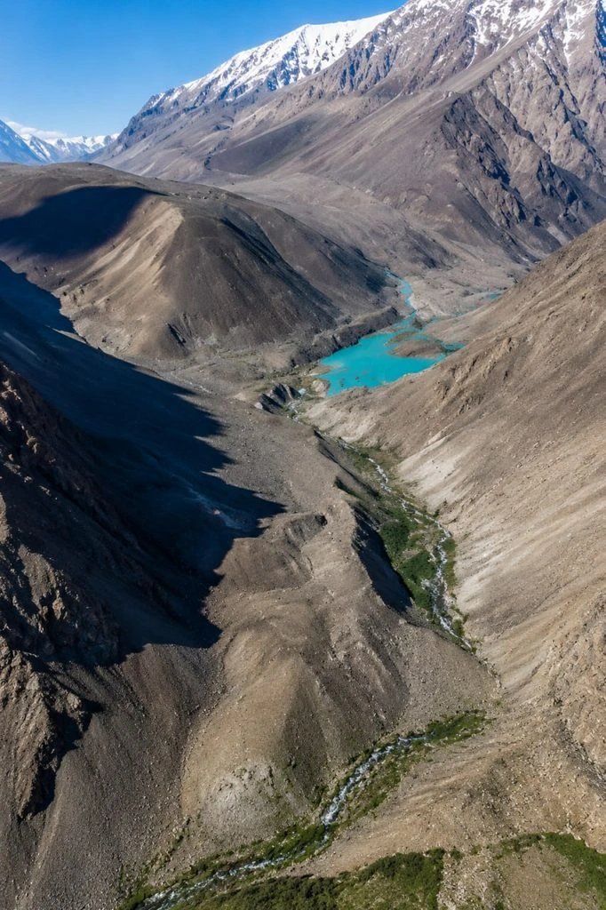
Tajikistan has begun using the automated THAW tool to detect new and abnormally changing mountain lakes that pose outburst flood risks. The system processes Sentinel-1 SAR satellite data on the Google Earth Engine platform. It is being applied to monitor Sarez Lake and other high-altitude water bodies in the Pamirs.
Key Facts
- The THAW tool uses Sentinel-1 SAR satellite data and the Google Earth Engine platform to detect lakes requiring additional observation.
- A practical workshop on THAW was held in Dushanbe with specialists from the Agency for Hydrometeorology, the Institute of Glacier and Cryosphere Studies, and the Institute of Water Problems, Hydropower and Ecology.
- According to research by Professor Abdulhamid Kayumov, Tajikistan has approximately 500–600 glacial lakes, with the number changing due to natural processes and climate change.
- Sarez Lake holds about 16–17 cubic kilometres of water behind a natural dam roughly 500 metres high.
THAW Monitoring System
Tajikistan has begun implementing the automated THAW tool to identify new and abnormally changing mountain lakes that are potentially dangerous due to outburst risk. The system uses Sentinel-1 SAR satellite data and the Google Earth Engine platform to detect water bodies requiring additional observation. A practical workshop on THAW was held in Dushanbe with specialists from the Agency for Hydrometeorology, the Institute of Glacier and Cryosphere Studies of the National Academy of Tajikistan, and the Institute of Water Problems, Hydropower and Ecology of the National Academy. Participants tested the system's ability to search for potentially emerging lakes in selected glacial basins of Central Asia.
Glacial Lake Hazards
Climate change is accelerating glacier melt and forming new unstable lakes in high-mountain areas, according to materials from the GLOFCA project on reducing vulnerability to glacial lake outburst floods in Central Asia. When such lakes burst, water can reach settlements, infrastructure, and agricultural land downstream. Danger arises when water accumulates behind an unstable natural dam, and such lakes can rapidly expand and burst after heavy rainfall, abnormal heat, landslides, or other factors. A burst flow can carry large volumes of water, rocks, ice, and mud, destroying roads, houses, and farmland. According to research by Professor Abdulhamid Kayumov, Tajikistan has approximately 500–600 glacial lakes, with the number changing due to natural processes and climate change.
Sarez Lake
Sarez Lake formed in 1911 after a strong earthquake when a large landslide blocked the Murgab River, creating the Usoi Dam, a natural barrier holding back the lake's water. According to a study titled 'Sarez Lake — assessment of potential hazard based on natural analogues of a presumed chain of dangerous events', the lake's water volume is about 16–17 cubic kilometres and the natural dam height reaches approximately 500 metres. The study's authors note that the Usoi Dam is currently considered stable with respect to water filtration and internal deformations, but satellite observations reveal slope movements around the lake. Researchers indicate that a possible large landslide into the lake could create an impulse wave capable of causing overflow over the dam and subsequent destruction.
1 source
Tajikistan deploys satellite tool to monitor glacial lake outburst risks